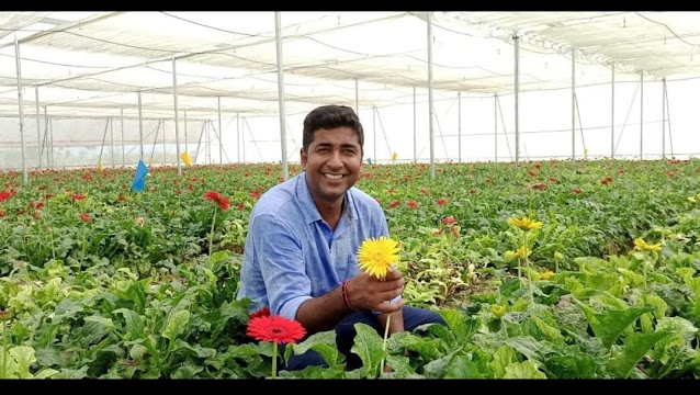
Welcome to Valley of the Flowers National Park, India!
Valley of the Flowers National
Park is located in the West Himalayas in Uttarakhand, India. This area
is also identified as the location at the latitude and longitude of
30.73 degrees north and 79.63 degrees east at an elevation of 11,000
feet (3,500 meters). The national park is known for it's meadows that
are saturated with unique alpine flowers as well as for the fact that it
is home to many endangered animals. Any sort of settlement has been
banned here since 1983 in an attempt to preserve it's beauty and to
protect the habitats of the animals that the park is home to. The park
is open to the public from June until October until it's grounds become
covered with snow when winter approaches.

Temperature
Temperatures in the lower elevations typically range from 7°C to 35°C. But temperatures tend to drop below freezing as you move up in elevation over the mountains. Glaciers and abundant snowfall in these locations are common in the winter months because of cold temperatures. Below is a chart of monthly temperature highs, lows, and averages from a nearby weather station in Roorkee, Uttarakhand, India.
(1)
Month | Average | High | Low |
January | 14.3°C | 21.0°C | 7.6°C |
February | 16.8°C | 23.5°C | 10.1°C |
March | 22.3°C | 29.2°C | 15.3°C |
April | 28.8°C | 36.0°C | 21.6°C |
May | 32.5°C | 39.2°C | 25.9°C |
June | 33.4°C | 38.8°C | 27.8°C |
July | 30.8°C | 34.7°C | 26.8°C |
August | 30.0°C | 33.6°C | 26.3°C |
September | 29.5°C | 34.2°C | 24.7°C |
October | 26.3°C | 33.0°C | 19.6°C |
November | 20.8°C | 28.3°C | 13.2°C |
December | 15.7°C | 22.9°C | 8.5°C |
The average monthly temperatures for Uttarakhand, India.
Precipitation
The Valley of Flowers experiences a monsoon season from June to September where they receive 70-80% of their precipitation (3). The park experiences accumulation of snow anywhere from 10 to 15 feet from late October to late March. The snow tends to accumulate a more deep amount at lower latitudes (2). Below is chart of rainfall in millimeters by month. As the graph shows, most of the precipitation occurs from June to September and the rest of the year is fairly dry.
Spatial distribution of rainfall in Indian Himalayas.
Humidity and Fog
Fog is common, particularly in the lower portions of the valley. Radiation fog occurs often overnight and in the early morning. The relative humidity in the valley ranges anywhere from of 44% to 87%. Relative humidity peaks during the monsoon season (June-September), and at it's lowest February into May because it is the end of the winter and the beginning of the monsoon season. July is normally the peak of humidity, with the highest average relative humidity and the highest number of precipitation days. Below is chart of monthly relative humidity and precipitation days.
(4)(5)
| Jan | Feb | Mar | Apr | May | Jun | Jul | Aug | Sep | Oct | Nov | Dec |
| Relative Humidity (%) | 75 | 63 | 56 | 44 | 56 | 75 | 87 | 86 | 81 | 71 | 69 | 70 |
| Precipitation Days | 5 | 8 | 8 | 3 | 13 | 15 | 20 | 19 | 14 | 3 | 0 | 2 |
Chart of the relative humidity and number of days there was rainfall in the Valley by month.
Wind Directions
During the beginning of the year, more specifically months January through March, winds blow from the east. The rest of the year continues with winds blowing from the southeast. Throughout the year, the average wind speed is 5.11 miles per hour. In the months of May and June the wind speeds fluctuate to be slightly higher, but never exceeds 6 mph throughout the entire park.
Graphical representation of the average wind speeds by location in Uttarakhand, India. Annual average wind speed broken up by month.
Global Wind Patterns
During the rainy season, months June through September, intertropical convergence zone (ITCZ) wind patterns affect the Valley of Flowers because of the proximity to the equator. Throughout the rest of the year, the northeasterly trade winds blow across the area due to dry air sinking and moist air rising. The latitude of this location is 30 degrees north, causing it to be affected by Hadley Cells, which is where air rises at the equator and sinks at about 30 degrees north and south.


Both
images illustrate the different kinds of winds, the movement of air,
and the different cells that correlate to a location's winds and
latitude.
Air Masses
Maritime Tropical (mT)
The air mass that primarily affects Valley of Flowers is the Maritime Tropical air mass. The source region for this air mass is in the Pacific ocean where it flows northwest, eventually hitting the Valley of Flowers. Maritime Tropical air masses are hot and humid and therefore, rain-producing air masses. These are the air masses that are responsible for the occurrence of the monsoon season. The location of Valley of the Flowers is far off the coast, making it a maritime air mass, and is far away from the poles, which eliminates any affiliation with the polar air masses.
(14) (15) (16)
Weather Systems and Severe Weather
Valley of Flowers is an area that is affected by the June through September summer monsoon season. During this time, the area receives an average of 1,749.7 mm of rain, with July and August being the rainiest months (3). This is primarily caused by the shifting in wind directions. During September through June, the winds blow from land to ocean (continental winds) which means that the the winds will be dry. When the winds shift to blowing from ocean to land (maritime winds), the wind becomes moist which creates precipitation and the monsoon season for this area. The monsoon season causes flash floods, landslides, and consequently crop damage all within the lower stretches of the valleys. In addition, severe thunderstorms also form in this area, most commonly during the monsoon season. These thunderstorms are a result of the high amount of moisture in the atmosphere which form cumulonimbus clouds and precipitation, as well as the high amount of lift which is directly related to the area’s elevation and location within the mountains.
(8) (9) (10) (11) (12) (13)
Temperature and Precipitation Regimes
The temperature regime is continental because the park is located so far inland and experiences temperature averages that do not drastically change throughout the year. The lowest average temperature that the location experiences is that of 14.3 degrees Celsius, whereas the highest average temperature is 33.4 degrees Celsius. This is only a difference of 19.1 degrees Celsius.
The precipitation regime is categorized as uniform as a result of the fact that precipitation occurs relatively constantly throughout the entire year. The monsoon season, which is June through September produces the largest amount of precipitation during the summer. During the winter, which is October through late March, there is precipitation through the form of snow. Therefore, as a result of the fact that Valley of the Flowers receives precipitation year-round, as opposed to just during the summer season, or “high sun” season, it is categorized in a uniform precipitation regime.
Climate Type and Characteristics
The
climate for Valley of the Flowers is classified as a Highland climate.
Highland climates are those climates that you would find in high
mountain areas. The climate for mountainous areas tend to vary as
elevation increases, therefore mountains have their own climate type.
This climate type lacks a dry season, instead there is precipitation
year-round.
Biome and Ecoregion
Biome: Montane Grasslands and Shrubland
This biome includes high altitude montane and alpine grasslands and shrublands.

Montane Grasslands and Shrubland Biome (29)
Ecoregion: Western Himalayan Alpine Shrub and Meadows
This
ecoregion represents the Himalayan shrublands and meadows between 3,000
and 5,000 meters. A fourth of the ecoregion is a bare composition of
rocks and ice. The ecoregion is home to animals such as Snow leopard, Musk Deer and Blue Sheep.
Western Himalayan Alpine Shrub and Meadows (28)
Climate Adaptation Affecting Animals and Plants
Animal Adaption
The climate of the Valley of the Flowers plays a large role in the adaptations made by animals, the greatest example of this is the Snow Leopard. The Snow Leopard has large feet that allow them to more easily travel over snowy terrain, smaller ears to retain body heat, a wide and short nasal cavity that warms cold air before it enters the lungs, and a very thick, long tail provides warmth to their face and body when lying down when they wrap it around their face. Considering it's adaptations, the Snow Leopard is perfectly engineered for the rocky, cold, and snowy environment in the mountains in the Valley of Flowers.
(22)
Snow Leopard's physical adaptations (23)
Plant Adaption
A species of tree that has been affected by and adapted to the climate in The Valley of the Flowers is the Himalayan Maple tree. This tree is indigenous to the middle to lower portion of the valley, commonly growing alongside streams and rivers. Since there is rainfall and mild temperatures in the lower regions of the area year-round the Himalayan Maple stays green year-round. This allows it to spread its wing shaped seeds, which flow in the winds through the valley. The Himalayan Maple has also adapted to the soil as a result of the fact that is it constantly moist due to rain and runoff, allowing it staying green year round and grow to great heights.
(24)
Himalayan Maple Tree leaves and seeds (24)
Topography Influences the Distribution of Plants and Animals
Elevation plays a large role in the distribution of plants and animals in Valley of the Flowers because the mountains and valleys produce varying terrain with different slopes. Vegetation decreases as you climb in elevation because there is less soil and more rocks, which plant roots have to compete with. The Valley of Flowers is surrounded by snow-capped mountain tops that create many rivers from glacial deposits. These rivers provide irrigation to the many colonies of flowers, enriching the vegetation in this region. Moist monsoon winds funnel towards the Himalayan mountain range, the eastern side of the mountains intercepting most of the precipitation. The western side receives less precipitation, creating a drier climate that influences vegetation (elevation declining from 4,000 m in the east to about 3,500 in the west). Two forest types can be recognized here; evergreen broad-leaved forests and deciduous broad-leaved forests. These forests are usually found on the more moist southern slopes, which are heavily influenced by the monsoon season.
(25)(26)
The Valley of Flowers, India
Environmental Threats
Invasive Species
The main environmental threat to the Valley of the Flowers is the invasive species of the Himalayan Knotweed, which is an incredibly invasive species that is almost impossible to control at some points. The Himalayan Knotweed has an extensive root system which
means that it is especially hard to get rid of; a root fragment
(rhizome) smaller than a penny is enough to rejuvenate it and cause
continual damage. The invasive root system and strong growth can cause
damage to concrete foundations, buildings, flood defenses, and roads. It
also forms
thick, dense colonies that completely crowd out any other herbaceous
species, has a tolerance of a very wide range of soil types, pH and
salinity, and it’s rhizomes can withstand many temperatures. The
species crowds
out other native species, alters natural ecosystems, is difficult to
eradicate, and can disrupt flood dispenses because of its potential for
such extensive growth.
Poaching
Most animals in this area, especially the snow leopard, are under constant threat from poachers. Due to the lack of training for high altitude patrol monitoring, the higher elevated locations where the snow leopards live are largely unregulated. Therefore, poachers are able to hunt virtually unnoticed at those elevations.
Pollution
Another threat to the Valley of the Flowers are bottles and other various items of trash being left around the park due to the high influx of tourists because of the park’s popularity. There are approximately 300,000 bottles left at the park every year. This is listed as the second biggest threat to the park behind the invasive Himalayan Knotweed but the park is employing many more people to help clean up these bottles and other various littered items, including fecal matter from humans and mules.
(27)
Rock Types & Geologic History
Valley of the Flowers contains bedrock which is made up of sedimentary rocks, mica schist, and shale rocks. These are very common in the valleys between the mountains that are present in the park. The mountainous slopes have caused the geology to form over time, and the Valley of Flowers was once covered by glaciers that retreated over time and caused the different types of rocks to form. The mountains themselves were caused by glacial erosion in the area over time. The most rocky areas are in the valleys of those mountains, with exposed bedrock containing multiple rock forms. (32)Sedimentary Bedrock (32)
Plate Tectonics & Events
Valley of the Flowers is located directly on top of a plate boundary (between the Indo-Australian and Eurasian plates) creating an mountainous environment. As a result of the fact that the park is located here, the location is at high risk for earthquakes. Seismic activity in this region is due to the trijunction of three mountain belts: the Himalayan range, Mishmi Hills and Naga Patkai range. The region near Uttarakhand in the Himalayas has witnessed 13 earthquakes of the same magnitude of 6 in last 97 years. This indicates the occurrence of one strong earthquake every 8 years. This region has been visited by two major earthquakes in last decade. Both of these earthquakes occurred in 2008. (33)
Plate Boundaries & Effect On Landforms
Valley of the Flowers is located in the western portion of the Himalayan Mountain range between two of the tallest mountains in the world. The plate boundaries that created the Valley of the Flowers and the western portion of the Himalayan Mountain range are the Indo-Australian plate and the Eurasian plate. This continent-continent convergence has created very tall and steep mountains. The process that created the U shape of the valley was the movement of glaciers in between the mountains smashing the rock into the shape that the valley possesses today. (33)
Indo-Australian Plate Boundary (34)
Weathering & Erosion
As part of the Himalayas, the Valley of the Flowers belongs to one of the largest erosion systems in the world. The Valley was largely shaped by weathering and erosion processes as streams and small rivers run through the valley, breaking off and carrying sediment downstream. More than a billion tons of sediment and dissolved materials is carried to oceans annually. This makes up an erosion rate of a few millimeters per year. In the long term, erosion can contribute to the carbon cycle through organic matter transport and burial and isostatic rebound of eroded areas plays a part in the tectonic evolution. In the short term, the Himalayan basin and its environment depends on erosion processes that affect the risks of landslides and glaciers, also helping control soil stability and fertility. Below is a figure that shows the combined effects of erosion, monsoons, and tectonic activity on the Himalayan valleys that has helped shape them today. (32)
(32)
Liquid Water & Watersheds
Valley of the Flowers is surrounded by prominent water features such as cascading waterfalls, the Hemkund Sahib Lake, and the Alakhnanda River. Another important feature is the Pushpawati River, which rises from the East Kamet Glacier at the base of the Himalayas. It flows southerly, draining and bifurcating the valley into two separate parts. Valley of the Flowers is located in the Ganges watershed, containing a medium recharge amount of groundwater which is about 20 to 100 mm per year. (35)(36)
The Pushpawati River flowing from the Valley Flowers (35)
Glaciers
Valley of the Flowers was primarily formed by the retreating of glaciers whose periodic advance and retreat pulverized hard rocks, resulting in a smooth U-shaped valley which was later and is currently colonized by numerous plants adapting themselves to the harsh climatic conditions prevailing in the area. Valley of the Flowers is surrounded on both sides by glaciers, many of which are capped with snow. Valley of the Flowers has become essentially the catchment area of the Pushpawati River, which is known as the Bhyundar Ganga, downstream of Ghangaria. It consists of a glacial corridor, 7 km long and 2 km wide, with it's source in the Tipra Glacier which descends from Gauri Parbat which is a mountain peak that is also commonly called “Horse Peak.” The Tipra Glacier is located about 3 miles from the Valley of the Flowers and it continues to shrink anywhere from 5 to 10 miles a year. (37)(38)
Tipra Glacier from Valley of the Flowers (37)
References
Powered by:
@AnandDewangan